Introducing the CLEARING HOUSE Spatial Impact Assessment and Classification tool – making trees benefits visible
By Sebastian Scheuer, Corina Basnou, Dagmar Haase
If you have followed the journey that is the CLEARING HOUSE project, you will already know or have learned that trees have manifold benefits for our cities, and therefore, for us. They help us to bring more biodiversity in our cities. They help us fight climate change by sequestering and storing carbon. They make our air healthier to breathe by removing both gaseous pollutants and particulate matter. On hot days, trees help to cool our cities. Have you noticed that you may feel a little better when you see trees out of your window? Do you feel more relaxed and better when you have visited a forest?
But are we able to capture the trees’ full potential and notice their benefits? Do we really understand and respect our trees? What can we do to help cities to embrace trees, even where solutions seem difficult?
To maximize the delivery of tree-based benefits, it is important to gain good understanding of our urban trees, for example, how many trees are there? Where are they? How connected are they with each other? What is the magnitude of benefits they provide? Generating knowledge on such current conditions on urban forests is important for their management, and to raise awareness towards them.
The Spatial Impact Assessment and Classification tool—SIAC, in short—is a tool developed by CLEARING HOUSE that is intended to support practitioners and researchers in finding answers to such questions. In so-doing, SIAC may also help to determine selected indicators on conditions of the urban forest, that are in line with key themes related to IUCN’s urban nature indexes, however, with tree cover being a key focus. By modelling tree cover, SIAC addresses the challenge of identifying (trends in) vegetation cover. Other indicators that SIAC provides include, for example, street tree density. This approach can help us know where to plant trees or take other positive steps to green our cities. In addition, SIAC assesses spatial relationships, inclusive of trees with streets or buildings, thereby providing insights into local conditions with respect to the 3 and 30 components of the 3-30-300 rule. Do you know that a recent study found that one-third of deaths attributable to heat islands could be avoided if trees covered 30% of urban space?
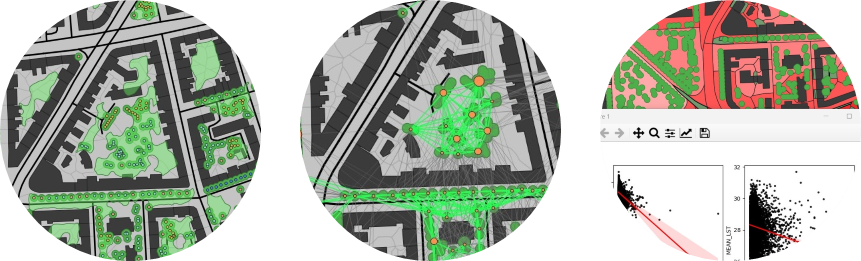
Individual trees and/or tree cover (left) are the basis for many of the assessments conducted by the SIAC tool, including the modelling of connectivity (middle) or the estimation of cooling benefits (right).
An important issue for maintaining the biodiversity in our cities is the connectivity of natural elements and habitants in urban environments. Here, SIAC seeks to estimate the connectivity of trees (networks) using a graph-based approach, and in so-doing, may help to identify tree-based entities that are important to maintain connectivity and thus enlarges habitats for urban wildlife, or determine where the planting of trees may improve connectivity.
To approximate the benefits of trees for human health and well-being, SIAC attempts to estimate pollutants removed to regulate air quality, and models the cooling potential of tree cover, with the latter allowing, for example, an estimation of the cooling benefits associated with an increase of tree cover. The combination of global warming and the expansion of the urbanised environment has led to the intensification of urban heat islands, accompanied by adverse effects on planetary health.
With the focus on providing first insights into local conditions and tree cover-related benefits, required data are comparatively basic but easy-to-understand, especially when compared to other applications. However, SIAC allows the easy integration and adaptation of information available in the cities. Therefore, SIAC should be comparatively easy to adopt. In addition, SIAC builds on principles devised in a trait-based typology on urban forests as nature-based solutions. This typology is intended to deliver a more systematic and integrative understanding of urban forests and nature-based solutions. Through the typologies’ systematic perspective, SIAC also seeks to facilitate a comparison of urban forest conditions and tree-based benefits across municipalities and case study locations.
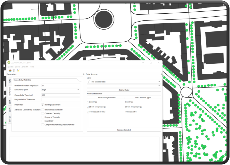
The SIAC tool is devised as a QGIS plugin.
The SIAC tool is made available free of charge as a plugin for the popular QGIS open-source geographic information system. Discover the full paper here: http://doi.org/10.5281/zenodo.10255287
Selected further reading
Iungman, T., Cirach, M., Marando, F., Barboza, E.P., Khomenko, S., Masselot, P., Quijal-Zamorano, M., Mueller, N., Gasparrini, A., Urquiza, J., Heris, M., Thondoo, M., Nieuwenhuijsen, M., 2023. Cooling cities through urban green infrastructure: a health impact assessment of European cities. The Lancet, 401(10376), 577-589.
Konijnendijk, C., 2022. Evidence-based guidelines for greener, healthier, more resilient neighbourhoods: Introducing the 3–30–300 rule. Journal of Forestry Research, 34, 821-830.
IUCN Heritage and Culture Team, 2023. The IUCN Urban Nature Indexes. Methodological framework and key indicators. Gland, Switzerland.
Scheuer, S., Jache, J., Kičić, M., Wellmann, T., Wolff, M., Haase, D., 2022. A trait-based typification of urban forests as nature-based solutions. Urban Forestry & Urban Greening, 78, 127780.
Turner-Skoff, J., 2019. The benefits of trees for livable and sustainable communities.