Spatial accessibility to urban green spaces in Brussels Capital Region and its surroundings
The benefits of urban green spaces (UGS) are significant for increasing the rate of physical activities, general improvement of health and ensuring an improved socialization culture in a society. The associated benefits are also essential for quality of life and wellbeing improvement. However, in many cases, UGS and therefore the benefits they provide are unevenly distributed in cities, which raises issues of environmental justice.
This blogpost focuses on the Brussels Capital Region (BCR) and its surroundings, referred to as the Greater Brussels Area (GBA). While other contributors to this blog have already examined this city’s environmental inequality (e.g. Charlotte Noël and Lucía Rodríguez Loureiro, or Lievin Chemin), in this post we present the results of an analysis of spatial accessibility. Spatial accessibility to UGS is an essential aspect about improving the level of access to UGS by urban residents. This is associated with enhancing the geographical or physical accessibility to UGS in terms of distance and time to reach the nearest UGS.
Approach to the Study
Geographic Information System (GIS) network analysis was used to assess the level of walking and cycling accessibility to UGS. This enabled a comparison between the different levels of accessibility. Also, UGS ranging from small-sized to large-sized were considered (>=2ha – small; >=20ha – medium; and >=100ha – large). Different-sized UGS provide varying opportunities to urban residents. UGS data from open street map (OSM) was used for the analysis. This consists of forests, parks, street trees, allotments, and cemeteries. Furthermore, an average speed of 5 km/h and 15 km/h were used for the walking and cycling time respectively. The maximum travel times considered for accessing small-sized UGS were 1 min and 5 mins for walking and cycling respectively. For medium-sized UGS, the maximum travel times were 24 mins (walking) and 8 mins (cycling). Moreover, large-sized UGS have maximum travel times of 60 mins and 20 mins respectively for walking and cycling. The service area function of the network analyst tool of ArcGIS 10.8.1 was applied to determine the number of residential houses that are within accessible ranges of different-sized UGS.
Results
Figure 1. Accessibility to small-sized UGS by walking and cycling
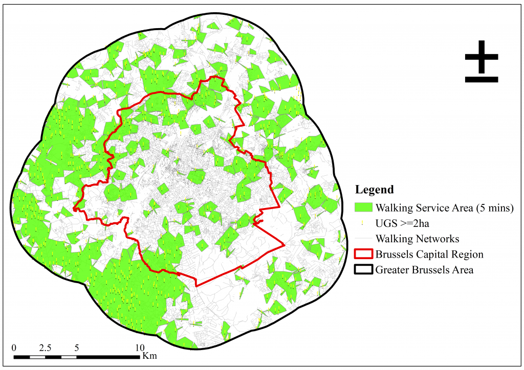
Small-sized UGS such as private gardens and trees provide a close connection between people and nature. Figure 1 shows that 39.4% and 64.0% of residential houses in the BCR have access to small-sized UGS by walking and cycling respectively. Also, 62.3% of residential houses in the GBA have access to small-sized by walking while 79.8% of residential houses in the GBA have access to small-sized UGS by cycling. This implies that a larger share of residential houses in the GBA have access to small-sized UGS by both walking and cycling compared to those in the BCR.
Figure 2. Accessibility to medium-sized UGS by walking and cycling
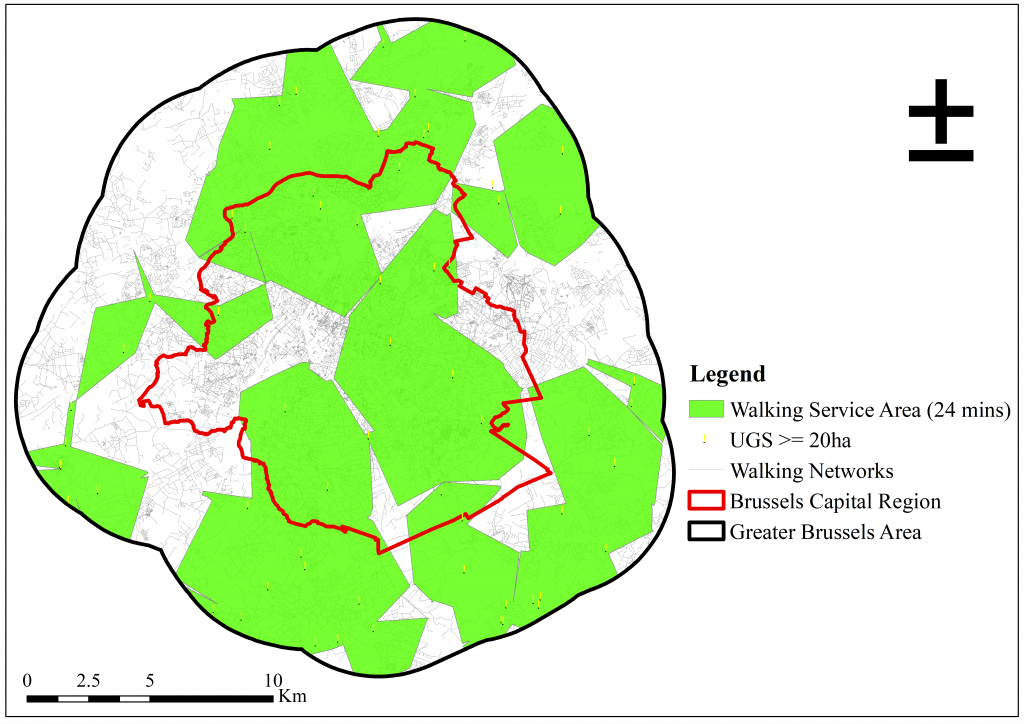

Access to medium-sized public parks encourages social interaction among residents. Figure 2 highlights that 76.2% of residential houses in the BCR have access to medium-sized UGS by walking with 61.6% of residential houses in the GBA. Moreover, 93.4% and 68.9% of residential houses have bicycle access to medium-sized UGS in the BCR and the GBA respectively. The results therefore imply that a larger share of residential houses in the BCR than in the GBA have walking and cycling access to medium-sized UGS. As such, this shows an opposite trend than the results found for walking and cycling access to small-sized UGS.
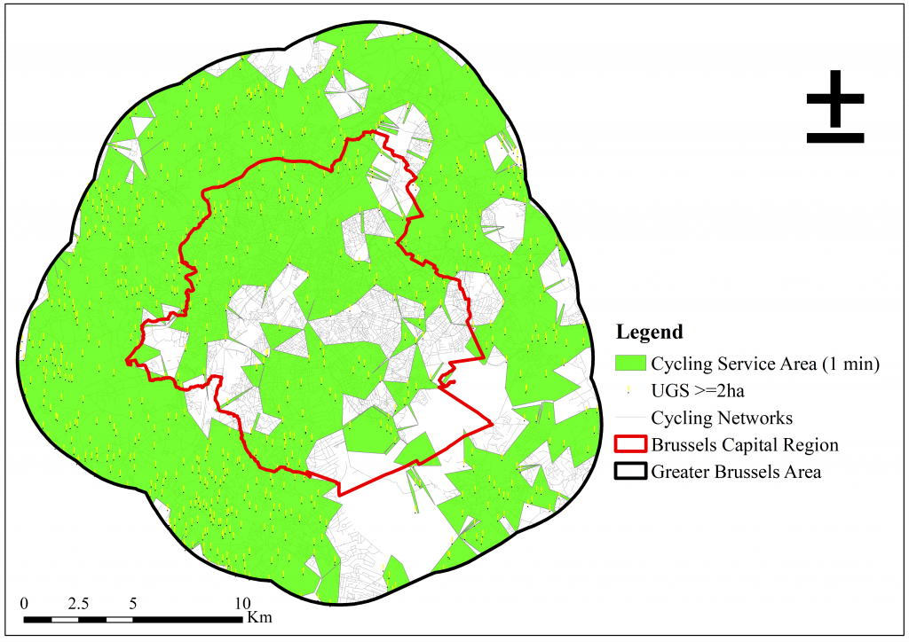
Figure 3. Accessibility to large-sized UGS by walking and cycling
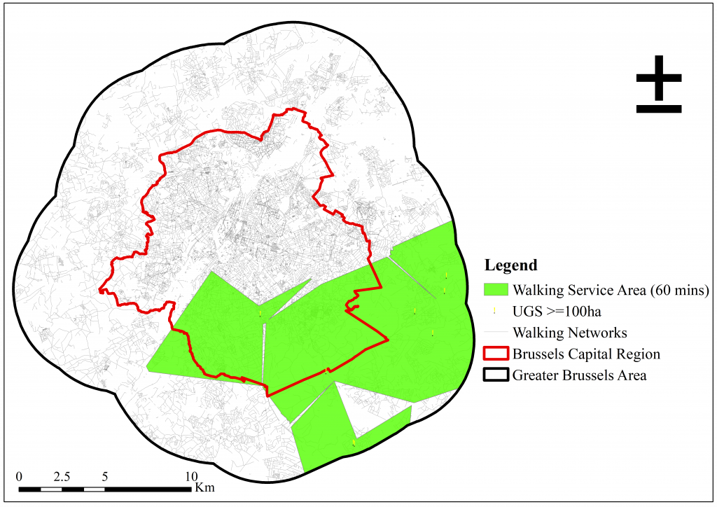

A variety of benefits are derived from large-sized UGS like forests which are essential for human wellbeing improvement. Figure 3 indicates that 23.2% and 17.4% of residential houses have access to large-sized UGS by walking in the BCR and the GBA respectively. In the case of cycling, 34.6% of residential houses in the BCR have access to UGS large-sized UGS while 25.8% have access in the GBA. This also implies that a larger share of residential houses in the BCR have access to large-sized UGS by both walking and cycling. This trend corresponds to that of accessibility to medium-sized UGS and differs from the accessibility to small-sized.
Conclusion
The results of the accessibility analysis have shown that a larger share of the population in the BCR has access to large-sized UGS (at least 100ha) than small-sized UGS (at least 2ha). This information would be useful for the city authority in planning, allocation, and management of UGS in the BCR, because there is a clear indication for small-sized UGS. The provision of small-size UGS could be a useful way of improving the level of accessibility to UGS in cities. The results of this study together with other available data can assist the local authority in making conscious effort for planning an improved UGS accessibility. Also, for the majority of the population, the cycling accessibility to UGS of various sizes is higher than their access by walking, encouraging cycling among people can also be a good way of improving the level of accessibility to UGS and, as such, overall health, and wellbeing. This can be achieved through the development of cycling infrastructure to reach UGS. These measures would help ensure UGS accessibility for all thereby addressing environmental justice issues in cities.
Authors
Rexford Osei Owusu was a research intern with VUB from November 9, 2020 to January 11, 2021 as part of his Master of Science (MSc.) Geo-information Science and Earth Observation for Urban Planning and Management Studies. Currently, Rexford is in the final phase of the programme working on his MSc. thesis titled “Urban Green in Deprived Urban Areas: The Case of Kumasi, Ghana”.
Nina Schwarz is an Assistant Professor at the Faculty of Geo-information Science and Earth Observation (ITC), University of Twente, The Netherlands.
Koos Fransen is a postdoctoral researcher at Vrije Universiteit Brussel (VUB).